
VIDEO: Routing a Path for Everyone
Video by UK Public Relations and Marketing. To view captions for this video, push play and click on the CC icon in the bottom right hand corner of the screen. If using a mobile device, click on the "thought bubble" in the same area.
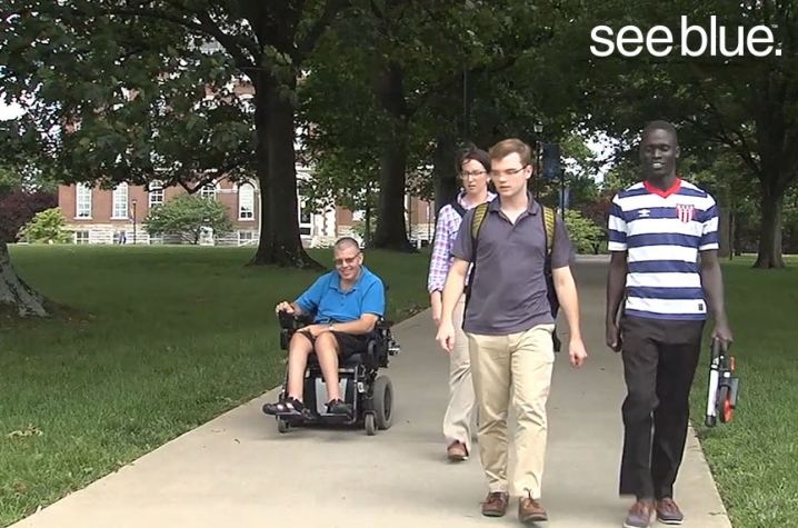
LEXINGTON, Ky. (July 1, 2016) — When Darrell Mattingly, a longtime University of Kentucky employee, heads to a meeting on campus, he often has to take a different route. Mattingly travels via wheelchair, and after years navigating the campus, he knows his way around. But for others — students, employees and visitors — with different types of mobility, the task can be difficult.
Mattingly, who works at the UK Human Development Institute and also attended school at UK in the '90s, said accessibility on campus has greatly improved over the years. But he knows just because there is a curb cut with a ramp at one entrance of a building doesn't mean others know about that option.
With around 400 buildings on UK's 800-plus acre campus, someone can spend a lot of time and energy searching for an accessible path leading to an accessible entrance.
So a group of students, led by HDI Disability Program Specialist Anna Bard, set out on a mission last year to map accessibility on campus so that everyone — no matter how they're navigating — can have the information they need to get around campus efficiently. In the fall 2016 semester, UK Facilities Management’s Facilities Information Services will unveil the new interactive campus map that includes accessibility attributes and can route an appropriate path depending on a user's needs.
"I think that this reaches all people and that's what we're trying to do as a community, as a university," Bard said. "We are looking to engage a diverse student body and we're looking to enhance workplace diversity and inclusion and to send the message to people with disabilities, and really all people, that we want to provide this information so that your campus is most usable to you."
The student team with HDI has collected data across the entire campus, including external pathways and entrances to buildings. Measurements of doors, sidewalks and slopes were logged in their iPads. They also noted the locations of every curb cut and a plethora of other accessibility barriers and solutions.
"Say you go out to Funkhouser … the handicapped accessible entrance is around back," said Sawyer Wilson, a mechanical engineering junior from Lancaster, Kentucky, on the team. "It's in the sub-basement; there's this little steep ramp that you would miss if you really didn't know where it was. What this map will do is tell people where on the building that is in order to give you the most accessible and easily possible route to get to that destination."
Bard added that while some folks may be able to navigate a 6 percent slope for 20 feet, those same individuals may not be able to navigate a 6 percent slope for 300 feet.
"We're just trying to document anything that might affect people's mobility on campus," she said.
And mobility and accessibility can significantly impact everyone's time on campus.
"It sort of sets up your entire day," Bard said. "If you can get to where you need to go quickly and you can do it fairly easily without struggling through multiple options or spending your time moving all through campus or all the way around the building — I think that you're going to show up to class or your meeting a little more motivated."
Noting that student success has been linked to how students plan their day, Bard said if students with disabilities are able to accurately schedule their classes — knowing the routes between each and the amount of time spent traveling —they have a better shot at being successful.
The initiative is already having an impact on the students working to collect data, helping them understand how people navigate space and instilling in them the value of creating a welcoming environment for every individual.
"I never realized that sidewalk is broken or there's a break in the pavement," said Marcus Garcia, a mechanical engineering junior from San Jose, Costa Rica, working on the project. "I just never think about that, but now every time I'm walking, I just see something that's not right and it comes to my mind ... now even when I go to the grocery store and there's not a curb cut in there, I just think about people with disabilities."
Garcia, Wilson and their team members are also obtaining skills that could give them an edge when it comes to their careers. They're learning universal design principles; gaining experience with AutoCAD and ArcGIS (software for design, drafting and GIS); and using technology like digital levels and door pressure gauges (a tool that measures how many pounds of force it requires to open a door).
"I'm really happy actually I'm doing it now that I am in college, not in the future, because I'm getting some very good experience," Garcia said.
Wilson added that after being involved in the project, he wants to incorporate accessible design into his career. Whether the students on the team are on their way to becoming engineers, geographers or landscape architects — the mission of this project, and of HDI, will be carried on for many years to come.
The mission to map accessibility on UK's campus actually began around 13 years ago. Volunteers from HDI and the Kentucky Geological Survey, a partner in the current venture as well, mapped as much as they could over a weekend. That information was hosted in an online and print map and on building information pages. But it lacked the interactive interface that users are familiar with today (think the Maps app on your mobile device).
"Which were very useful, but move forward, you know, 13-14 years, and it's just not the way that we are interacting with maps now," said Bard, who earned a bachelor's degree in geography and a graduate certificate in digital mapping from UK. "Not to mention campus changes a lot, so throughout those years there have been a lot of physical changes to campus, but also in the way that we use technology."
The accessibility and mobility features collected by the HDI team will be implemented into the official interactive UK Campus Map, online and in the myUK Mobile app, and that's where UK Facilities Management’s Facilities Information Services takes over.
"I'm not aware of any interactive or dynamic accessible maps on other campuses, not quite like this will be," said UK GIS Coordinator Michelle Ellington. "I think it will level the playing field for anyone needing to find their way around campus."
Ellington is leading a team working to find a way to communicate accessible attributes and options in the best way possible. She said the map will not only show people how to get to an accessible door, it can also provide detailed information — like width of the door or curb cut nearby — "for anyone who needs to dig a little deeper to find a route that works for them."
While the task may seem like a simple data dump into the current map, it's really a heavy duty programming effort with a complex geometric network and many moving parts.
"It's an exciting project requiring out-of-the-box thinking," Ellington said.
Exciting, and meaningful, for everyone involved.
"There's all sorts of people navigating our campus and if we can help them do that quickly and safely, then, you know, we're all better for it," Bard said.
UK is the University for Kentucky. At UK, we are educating more students, treating more patients with complex illnesses and conducting more research and service than at any time in our 150-year history. To read more about the UK story and how you can support continued investment in your university and the Commonwealth, visit uky.edu/uk4ky. #uk4ky #seeblue
MEDIA CONTACT: Whitney Harder, 859-323-2396, whitney.harder@uky.edu