
New Maps Plus Team Reveals Application of Advanced Technology
LEXINGTON, Ky. (March 17, 2016) — University of Kentucky geography Professor Matthew Zook and his team have created a particularly timely online map featuring America’s current sporting obsession – the NCAA Division I Basketball Tournament. The project effectively illustrates what can be done with a New Maps Plus education, UK’s new online graduate curriculum for a new era of life plotting. The New Maps Plus curriculum is an innovator in digital mapping, including both graduate certificate and master’s degree programs.
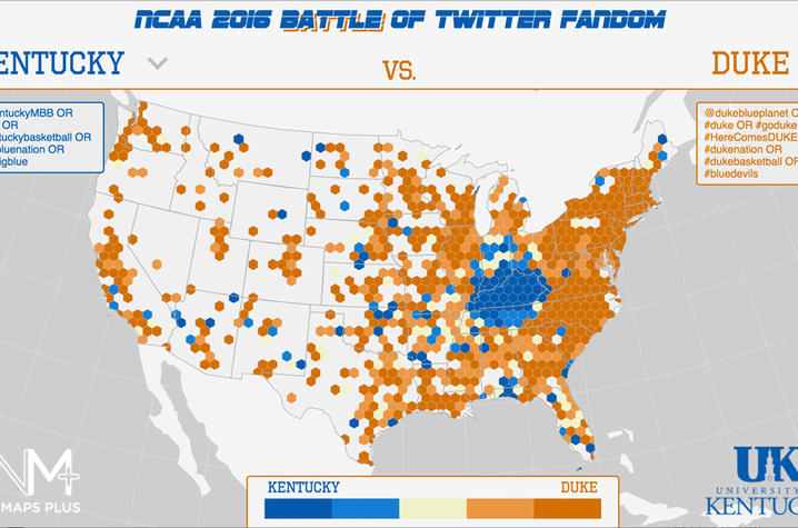
Zook and Rich Donohue – members of the New Mappings Collaboratory, the College of Arts and Sciences’ extensive initiative in the Department of Geography – created a visualization of the fan base for all 68 teams in the NCAA tournament by counting the numbers of geotagged tweets with certain hashtags and analyzing the frequency of those tweets across space.
They first collected data associated with Twitter accounts for the top 110 teams, paring it down to the lucky 68 men’s basketball teams to play in the 2016 NCAA tournament. They collected data for up to six hashtags associated with each team or school. Then, they conducted searches comparing that information with UK’s North American database of geotagged tweets, collected since 2012.
They refined the data using team or school tweets from the past four years. This translates into a time-sensitive geography of current college basketball fandom. Fans can use the resulting maps to compare the distribution of tweets between two specific schools, UK versus Duke, for example.
Fans can view NCAA 2016 Battle of Twitter Fandom at http://newmapsplus.github.io/march-madness-fandom-2016/
“Drawing on both applied and conceptual traditions in mapping practices and mapping thought, New Maps Plus represents a stream of scholarship centered at UK and focused on public engagement, ‘big data’ and user-generated Internet content, as well as the affordances of place-based thinking, analysis and representation,” explained Zook,
As a catalyst for mapping engagements on and off campus, New Maps promotes creativity, excellence and interaction around emergent mapping technologies.
The idea for the New Maps Plus program came from the realization that there were very few graduate programs designed to educate people about the robust range of new and exciting open source mapping tools. “Digital mapping has transformed over the last five years and has become much more accessible and cheaper for people to use,” said Zook, who is Kentucky’s state geographer.
“Our team began experimenting with new ways to geovisualize social media at the FloatingSheep website over five years ago and that really set us on this track,” he said. “We want to leverage open-source mapping tools to help people use maps to tell their stories and better understand the world around them.
“Maps are all around us, in our phones and in our browsers. Folks who want to learn how to do this are exactly the kind of people we want,” said Zook. “They can start from ground zero and in a couple of months they can begin making dynamic and interactive online maps.”
The proposed master’s degree in digital mapping and cartography is designed to serve the expanding landscape of mapping. This includes new professional sites and applications where maps are made by various people, from small business owners to non-profit managers to marketers, using all kinds of often freely available software and websites.
“Although this is targeted at graduate education, we'll see plenty of spillover into undergraduate education as well,” said Zook. “We're already introducing some of the same technologies in the first semester for undergraduates at UK, and our students are doing some amazing work.”
The curriculum takes a new and rather unique approach to mapping that the team hopes will push mapping into a whole new range of applications, from non-profits to business. Previously, mapping has been fairly concentrated in certain industries, like local governments or engineering, largely for reasons of cost. GIS software has tended to be expensive and only a few enterprises could devote the necessary resources. The curriculum focuses on open source mapping software precisely because it opens up mapping to whole new range of users, previously deterred by cost.
The curriculum is focused on helping students develop the technical skills and design fluency needed to make elegant and impactful web maps. But even more importantly, the courses will also teach students to think critically about the social dimensions of the maps.
“Maps, after all, are powerful things: they shape what we see and what we don't, with serious implications for how we come to know the world,” said Zook.
UK is the University for Kentucky. At UK, we are educating more students, treating more patients with complex illnesses and conducting more research and service than at any time in our 150-year history. To read more about the UK story and how you can support continued investment in your university and the Commonwealth, go to uky.edu/uk4ky. #uk4ky #seeblue
MEDIA CONTACT: Gail Hairston, 859-257-3302, gail.hairston@uky.edu